
Are you up to doing the Alton hill walk, a slightly challenging, 18km circular walk taking in the 6 hills on the fringes of Alton? Alton is in easy reach of Winchester, about 18 miles to the north-east.
 click on each of the six hill symbols to reveal the name and elevation of the hill
 full screen mode
 zoom in
 zoom out
 compass to orient the map – north at the top
 locate your current position on the map (browser will ask for permission, works best on phones due to use of GPS). We don’t track your location.
 opens the walk in a separate window in OSMaps. It will open in a separate browser tab, unless you have the iOS/Android app installed. In that case the app is directly openend. OSMaps offers additional functionality, like recording your walk, 3D-fly-throughs and access to Explorer and Landranger topographic maps.
Phone/tablet/touchscreen:
– Tap on symbols for more information about the walks and starting points
– Pan map: Tap on map and drag into any direction
– Zoom In/out: Pinch with two fingers
– Tilt map: Tap with two fingers and drag up or down
– Rotate map: Tap with two fingers and rotate
Laptop with mouse:
– Click on symbols for more information about the walks and starting points
– Pan map: Left click on map with mouse and drag into any direction
– Zoom In/out: Mousewheel or ‘+’ ‘-‘ keys on keyboard
– Tilt map: Right click and drag mouse pointer up or down
– Rotate map: Right click and drag mouse pointer left or right
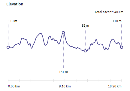
Elevation profile of the route
Description of the Alton hill walk route by walkalton.org. The walk was proposed by local walker Robert Athis in 2013 and officially launched by Alton Town Council in 2018.
Have a look at our other walks in Hampshire.